Data from the ancient “golden river” in Jordanian city of Jerash can help improve today’s sustainability
In the ancient Jordanian city of Gerasa – near the modern city of Jerash – new research has revealed that a so-called “golden river” enabled the city’s population to exploit the hinterland, which increased productivity and created more robust social and economic networks. Meanwhile, the surrounding terrace system for agricultural use was kept from deterioration and overexploitation. The sustainable administration of ancient land can be an inspiration for ways to master sustainability today. The discovery is described in a new study from Professor Rubina Raja, head of center at the DNRF Center of Excellence UrbNet, together with colleagues from the Danish-German Jerash Northwest Quarter Project, among others.
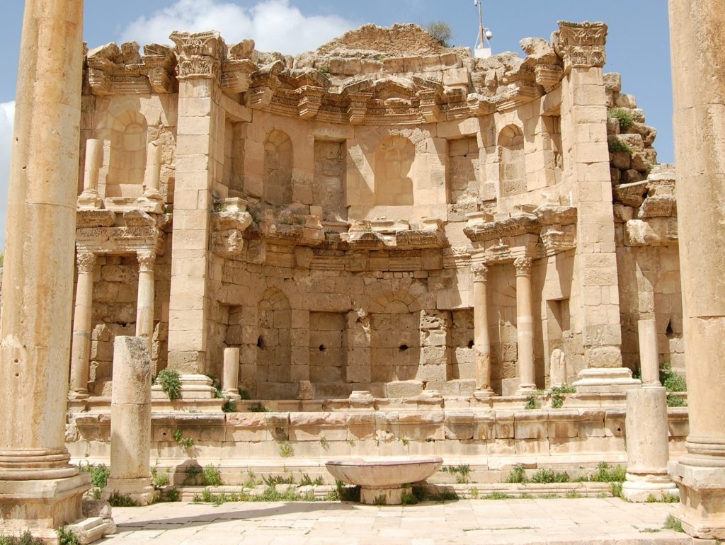
A new study presents data from archeological examinations of sediments from a so-called “golden river” that ran through the ancient city of Gerasa, from which ruins can still be seen in the modern city of Jerash in northern Jordan. The data from the river sediments reveal that the ancient city administered its hinterland and agricultural resources in such a way that the city was environmentally sustainable during wet phases. Behind the study are, among others, head of center at the DNRF’s Center for Urban Network Evolutions (UrbNet) Rubina Raja and research colleagues from the Danish-German Jerash Northwest Quarter Project.
“In the Roman and Islamic period, the administration of agricultural areas centralized. The soil was owned by the elite, who organized manpower and ensured that the land was cultivated, and the areas maintained,” Professor Raja told the DNRF.
Earthquake devastates city’s sustainable agriculture
Gerasa is a well-kept ancient city in northwestern Jordan. The city was established in 100 BC and was a part of the Decapolis for many years: a group of city-states with close relations to the eastern front of the Roman Empire. Across the city center ran the river Chrysorrhoas, also known as “the Golden River,” which had a great influence on the city’s urban development. When a big earthquake hit the area in 749 AD., the hinterland, which was organized as agricultural terraces around the river, was no longer maintained and the terraces, therefore, eroded tremendously. Due to the devastating earthquake, only smaller and shorter settlements were sustained in Gerasa at the time. Professor Raja and the rest of the research team have now collected data from the riverbed, which reveal differences in the intensity of the city’s administration of the hinterland and the riverbed in periods with climate change or political disturbances.
“One of the very surprising results is, it seems, that at the moment one stopped organizing and maintaining the hinterland (terraces), it began influencing urban life – meaning: lesser administration, cultivation, and maintenance of the hinterland equals a decrease in urban life. This indicates that the administration of the hinterland was optimized – and that it was important to maintain it in order to avoid erosion and flooding,” said Raja. She added:
“This, therefore, indicates that in order to avoid devastating the ecosystem that has been created, one should keep some level of exploitation, despite the fact that today we speak a lot of ‘overexploitation’ of the soil and agricultural land. In other words, this means that human influence is not equivalent to a deterioration of nature but that it also can have an important and necessary influence on the development.”
River sediments reveal historical processes from the past
Sediments from river systems are sensitive indicators on the landscape and environmental changes, and by examining the deposits, the researchers can dive into the archive of the bottom of the soil and discover much more about the natural processes and the human activity that existed at that time. Data from the sediments in the river turned out to refer to material from around 800 years leading up to the earthquake as well as 800 years after. This means that the terrace systems – even before the first millennium – had a big influence on the city’s agricultural life, something that is still true today.
In the study, the researchers used a method called optically stimulated luminescence (OSL), which is a new way to collect samples. The OSL samples can reveal both absolute and relative chronologies in relation to the processes that the sediments have undergone, which can be directly linked to the archeological data from Jerash.
“Optically stimulated luminescence is a dating method where one measures doses from ionizing radiation. The method, which is efficient for measuring over long periods of time, is used when working with historical eras and optimally in combination with other methods to achieve the highest precision to double check the results,” said Raja. She added:
“In our situation, we combined contextual archeological and the dating of discoveries from these contexts with OSL as well as 14C dating. This gave us the ability to be more precise in our dating than what would otherwise have been possible – it is high definition archeology, an area where we at the center wish to be frontrunners.”
The new study from Raja and the rest of the research team gives a better insight into and more in-depth knowledge about the fine line between human actions and environmental changes as catalysts to historical processes.
Read the scientific article in Taylor and Francis Online here